Sort Layers and Groups - GIS Integration
There are three options for changing the order in which layers and groups are displayed List by Drawing Order, List by Source, and List by Sort Order. Learn the details of each one below.
Navigate to the GIS Integration Module
To navigate to the GIS Integration module:
- From the NEXGEN dashboard, click Settings in the blue sidebar to the left.
- Click Integration.
- Click GIS.
Choose How Layers and Groups Should be Listed
Click the List By Sort Order tab in the top left to select how layers and groups will be listed.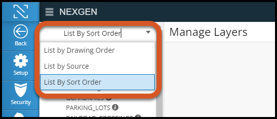
List by Drawing Order
This option displays layers and groups in the order in which they were brought into NEXGEN.
List by Source
This option displays layers and groups exactly as they are in the GIS database.
List by Sort Order
This option allows you to manually adjust the order of layers and groups within NEXGEN. To change the order of a group/layer, click and drag the group/layer name the new location.
Related Articles
Edit GIS Features - GIS
Users in NEXGEN have the ability to edit GIS layers directly from the GIS module in NEXGEN. Before being able to edit GIS features, GIS settings must be configured correctly by system administrators and GIS users must enter the proper login ...GIS Overview - Web
NEXGEN's GIS module allows users to view their linear assets from within their maintenance management system. From the map, NEXGEN users can add new work orders for multiple assets, review asset information, and more. GIS Overview Video Accessing the ...Group Layers
GIS Layers can be grouped under a parent layer in NEXGEN. This applies to both feature and map service. Grouping layers allows for better organization of layers and also gives the ability to turn groups of layers on or off while using the map in ...Import Layers from Multiple Map Sources
Users can import GIS layers from multiple map sources.This new feature gives clients the ability to mix and match layers from multiple existing map sources instead of needing to combine layers on one map before importing. Users can then edit GIS ...Legend and Layers
Learn how to turn asset layers on and off to view assets on the map. The legend shows which symbol represents each asset layer on the map. Video Overview Asset Layers In order to view assets on the map, the correct asset layer must be turned on. ...
Recent Articles
NEXGEN Admin Webinar Series (Part 7: Workflow Automation & User-Defined)
Video Guides: How to Use NAMI Dashboards
Accessing NAMI Dashboards Learn how to locate and access NAMI Dashboards within Work Orders, Service Requests, and Preventive Maintenance. Changing Tabs and Interactive Functionalities See how to navigate dashboard views, explore different metrics, ...June 2026 New Feature Webinar
Latest Phone Release - Version 2.0.5 (June 2026)
Phone Application Updates Asset Inventory Users can now type in an asset QR code in the search bar to find an asset in addition to scanning. (#23758) Form A quick action button to create a form will now be visible in the Hotspot. Users can tap to ...iPad Version 3.0.6 (April 2026)
iPad Updates Bug Fixes Resolved comments cutting off on mobile devices. (#24035) Fixed the issue of a Flag label unintentionally showing when completing assets. (#26071) Users should now be able to request items that are at zero quantity from the ...